i-Boating:Marine Navigation
- 4.1
- Rating
- 1.00M
- Installs
- Free
- Price
 Analysis by App-foxy
When I want a clearer picture of a day on the water, I usually need more than a basic map. I want to know where the channel runs, whether a shallow area deserves attention, how the weather may affect the trip, and whether I can still make sensible decisions when the phone signal becomes unreliable. That is the problem i-Boating:Marine Navigation tries to solve. It is a free Travel & Local app from Gps Nautical Charts that brings nautical charts, lake-depth information for fishing, and marine weather into one mobile workflow.
I approached it as I would before an ordinary outing rather than as a specialist navigator preparing a long expedition. The useful question is not simply whether the app contains charts. It is whether it helps me move from a vague plan to a safer, more informed route without creating a new set of distractions. My overall impression is positive: it can be a practical chartplotter companion, especially for boaters and anglers who want more context than a standard road-map app provides. At the same time, it rewards preparation and should not be treated as a replacement for proper nautical knowledge or backup equipment.
From a rough plan to a usable boating picture
I like to begin with the trip’s broad outline rather than chase a precise route immediately: identifying the water, checking the chart at two scales, and keeping a nearby fallback can make a phone-based plan more useful without making it more complicated. That preparation also gives me a better way to judge how much I should rely on the screen once I’m underway.
You May Also Like

 Blood Strike: 2.5 Anniversary
Blood Strike’s Loadouts Turn Every Drop Into a Tactical Gamble
A close look at Blood Strike’s custom loadouts: how fast access to signature weapons reshapes its battle royale rhythm, rewards preparation, and narrows the gap between fights.

 Pandora - Music & Podcasts
Pandora’s Music Is Easy to Start, but Harder to Recover
Pandora’s strength is its low-effort path from a seed to a station. Its weak spot is how much confidence it asks you to place in connection, setup, and quiet recovery.

 8 Ball Pool
 Is Built on Rivalries, Rematches, and Routine
A close look at the rivalries, rematches, shared routines, and unanswered safety questions that turn a quick pool match into a persistent mobile community.

 Samsung Music
’s Quiet Strength Is Playing What You Already Own
Its reach comes less from spectacle than from dependable access to a personal library. That simplicity is both the app’s strongest retention engine and its ceiling.

 AccuWeather: Weather Radar
AccuWeather Review: A Quick, Clear Forecast for Everyday Decisions
For everyday plans, the best forecast is the one you can understand quickly. AccuWeather makes rain timing, radar, and local conditions easy to act on, with a few trade-offs.

 Hill Climb Racing
Why Hill Climb Racing Still Turns Crashes Into One More Run
A tiny car, a bumpy hill and one more upgrade: Hill Climb Racing keeps resurfacing because its simple chaos makes every near-miss feel personal.
More From Our News Desk



Beginning with the real starting condition
A typical session starts with an incomplete idea: I know the lake, harbor, coastline, or fishing area I want to visit, but I do not yet have a clear route. Opening a conventional map would show roads and general geography, yet it would not answer the questions that matter on the water. i-Boating is designed around that different starting point. Its focus is marine charts, lake-depth maps, fishing use cases, and weather rather than land travel.
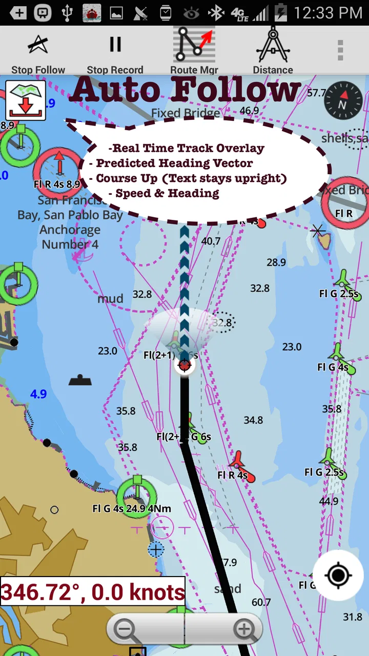
That focus is immediately useful when the destination is not simply a point on shore. I can think about the approach to a harbor, the shape of a lake basin, or the relationship between a fishing area and nearby depth information. The app’s store summary describes it as a chartplotter with lake-depth maps, fishing support, nautical and marine charts, and marine weather. In practice, that combination makes the first planning stage more structured: I am not only asking where to go, but also what the water may look like along the way.
The app is free to install, which makes it easy to test before committing to a particular boating routine. It is rated for Everyone, and its minimum operating-system requirement is Android 5.0, so it is accessible on a wide range of older Android devices. The developer is Gps Nautical Charts, and the app has reached over a million installs with an average rating of 4.2 from around thirteen thousand ratings. Those numbers do not prove that it will suit every region or boat, but they do suggest that it has been used as more than a niche experiment.
Choosing the right chart before leaving home
The first practical habit I would recommend is selecting and inspecting the relevant chart before arriving at the launch point. A phone is a poor place to discover how an unfamiliar interface works while the boat is moving. At home, I can zoom in and out, compare the broad shape of the area with the detailed sections, and decide whether the screen gives me enough information for the trip I have in mind.
This is also where expectations need to be realistic. A nautical chart is not the same thing as a road map with a blue background. Symbols, depth information, shoreline details, and navigational references require attention. I would not rely on a quick glance or assume that the most visually prominent line is automatically the safest route. The app can organize information, but I still have to interpret it correctly.
For fishing, the starting condition is slightly different. Instead of beginning with a destination marina, I may start with a target area and use the lake-depth view to understand how changes in depth could influence where I spend time. That does not turn the app into a guarantee of a successful catch. Its value is in helping me replace random movement with a more deliberate plan, especially when I want to investigate several areas without constantly switching between unrelated tools.
Building a route while keeping the phone secondary
Once I have identified the area, the next step is to work through the route. I find the app most useful when I treat the screen as a planning surface rather than as something that deserves continuous attention. I can examine the intended path, note likely turning points, and think about where the route may become more demanding. This is a subtle but important distinction: a chartplotter should support decisions, not encourage me to stare at a phone instead of watching the water.
A good workflow is to prepare the route in stages. First, I look at the whole area so I understand the relationship between the start, destination, and surrounding water. Next, I inspect the narrower sections and any depth information that could change my plan. Finally, I check the weather context and decide whether the route still makes sense. This order prevents the weather view from becoming an isolated forecast and prevents the chart from being treated as if conditions were fixed.
The strongest habit with this app is to use it before departure, not only during departure. Preparation exposes the app’s strengths while reducing the risk that a small interface problem, a slow chart view, or an unexpected change in conditions will become a crisis on the water.
Using marine weather as a decision point, not decoration
Weather information has more value when it changes the plan. If I am considering a short trip close to shore, the marine-weather layer can help me decide whether the outing is sensible at all. If I am already committed to a route, it can prompt me to shorten the trip, choose a more sheltered direction, or postpone the launch. The important handoff is from information to judgment: the app can present weather context, but I remain responsible for interpreting it alongside local knowledge and what I can actually see.
I would avoid treating a single forecast view as a complete safety assessment. Conditions on open water can feel very different from conditions at the launch site, and a forecast can change. The app is therefore more useful as one part of a pre-trip check than as a final authority. I would still compare it with the information available through local marine services and use direct observation once underway.
Understanding the handoff from phone to boat
The most important handoff is from the app to the person operating the boat. A route displayed on a screen does not remove the need to watch for traffic, floating objects, changing visibility, shoreline hazards, or other practical concerns. I would keep the phone positioned where it can be checked briefly without becoming the center of attention. If the boat has dedicated navigation equipment, I would regard i-Boating as a useful companion rather than automatically making it the sole source of guidance.
There is another handoff between the person planning the trip and anyone else on board. Before leaving, I can show a companion the broad route, the intended fishing areas, and the points at which the plan may change. That shared understanding matters because a navigation app is less helpful when only one person knows what the screen means. Even a simple verbal explanation of the route can make the trip calmer if the operator needs to concentrate elsewhere.
The app also sits between different kinds of information. The chart gives geographic and navigational context, depth maps support fishing and water-awareness decisions, and marine weather affects timing and route choice. I find the combination more useful than any one layer alone, but only when I deliberately connect them. Looking at each screen separately can create false confidence; asking how they affect one another produces a more realistic plan.
A realistic lake-fishing workflow
Imagine I am planning a morning on an unfamiliar lake. Before driving to the ramp, I open the app and locate the lake rather than waiting until the boat is moving. I inspect the depth map to identify several areas worth exploring, then look at the surrounding chart so I understand the shape of the shoreline and the route between those areas. I check the marine-weather information and decide whether the planned distance and timing still feel appropriate.
At the ramp, the phone is no longer where I make every decision. I already have a general sequence in mind: start with one area, move to a second if conditions or activity make that sensible, and keep an alternative closer to the launch point. During the outing, the app helps me reorient when I need to confirm my position or reconsider the next move. The result is not a magical fishing prediction. It is a more organized day with fewer unnecessary searches and less dependence on memory.
This workflow reveals a non-obvious strength: depth information is most valuable when it helps me plan transitions, not just identify one attractive spot. A route between several candidate areas can matter as much as the spots themselves. If the weather changes or time runs short, having a nearby alternative already considered is more useful than having one theoretically perfect destination.
What the free version means in practice
The app is free, but it includes in-app purchases ranging from $9.99 to $64.99 per item. That matters because the initial download is not necessarily the end of the cost decision. I would install it first, inspect the areas and workflow that matter to me, and only then decide whether an optional purchase is justified for my boating needs.
This approach is especially important for occasional users. Someone who takes one holiday trip may find a free test sufficient for deciding whether the interface feels comfortable. A regular angler or skipper may see more value in paying for the coverage or capabilities needed repeatedly. The sensible trade-off is to judge purchases by the specific waters I use, not by the size of the feature list.
In other words, the free entry point lowers the barrier to experimentation, while the in-app purchase range means serious users should think about long-term value. I would not buy anything simply because the app looks comprehensive. I would first confirm that it supports my actual lake, coastline, or boating routine and that I understand how the purchased material fits into my preparation process.
Where it is better than ordinary map apps
Compared with a normal mapping app, i-Boating is better aligned with water-based decisions. Road maps are excellent for reaching a marina or launch site, but they are not designed to explain a lake’s depth profile or present nautical chart information. Switching between a road map, a separate weather service, and another fishing reference can also make the planning process fragmented.
The advantage here is not that one app can replace every source. It is that the chart, depth-oriented fishing information, and marine-weather context are brought into the same boating conversation. That reduces the mental cost of moving from “where is the place?” to “how will I use the water once I arrive?” For a casual boater, that may be enough to make a trip feel more deliberate. For an experienced navigator, it may be a convenient secondary view.
Dedicated chartplotters still have important advantages for people who spend a great deal of time offshore or require equipment built specifically for continuous marine navigation. A phone can be easier to carry and cheaper to try, but it is also more vulnerable to battery limitations, glare, handling issues, and the distractions of a general-purpose device. I see i-Boating as strongest in the planning and companion-navigation role, particularly for smaller outings and inland-water use.
Three details that improve the workflow
My first practical tip is to create a plan with a fallback before launching. The depth map may suggest an appealing area, but weather, boat traffic, or time can make it unsuitable. Marking or remembering a second option closer to the starting point turns the app from a destination finder into a flexible planning tool.
Second, I would inspect the chart at both a broad and a close scale. At the broad scale, I can understand the overall shape of the trip and avoid planning a route that is awkward simply because two points look close together. At the close scale, I can study the local context around turns, shorelines, and likely stopping areas. This two-pass method is more reliable than staying zoomed in from the beginning.
Third, I would separate chart confidence from weather confidence. A clear chart view does not mean the conditions are favorable, and a reassuring forecast does not mean every shallow or restricted area can be ignored. Treating those as separate checks prevents one type of information from giving me false confidence about the other.
A fourth useful habit is to explain the route to another person before departure. If I need to focus on steering or communication, a passenger who understands the intended direction and fallback plan can help notice when the trip is drifting away from the original objective. This is a small handoff, but it makes a phone-based workflow less dependent on one pair of eyes.
Where the flow breaks down
The biggest weakness is that the app cannot remove the uncertainty of real water. A chart is only useful when I understand its symbols and limitations, and a depth view is not a substitute for cautious observation. Beginners may open the app expecting a simple turn-by-turn experience like driving navigation and feel overwhelmed by the amount of interpretation required.
There is also friction in relying on a phone during an active trip. Screen visibility, battery life, mounting, accidental touches, and general device handling all matter. I would not want the app to be my only navigation resource on a demanding journey. A paper chart, a second navigation method, or dedicated marine equipment may be the better choice when the consequences of losing the phone view are serious.
The purchase structure can also make the decision less immediate. Because the app is free to start but offers paid items, a user may need to spend time working out what is included for the waters they care about. That is not automatically a flaw, but it means the app is not as simple as downloading it and assuming every chart-related need is covered.
Another limitation is fit. Someone who only needs driving directions to a marina will probably find a normal maps app faster and less specialized. Someone who wants detailed professional-grade equipment for demanding offshore navigation may prefer a dedicated chartplotter. i-Boating occupies the middle ground: more relevant to boating than general maps, but still dependent on the phone and on the user’s own judgment.
Who should try it and who should skip it
I would recommend it to recreational boaters, lake anglers, travelers exploring unfamiliar waterways, and anyone who wants to combine nautical chart context with depth-oriented planning and marine weather. It is particularly appealing if I am tired of switching among several general-purpose apps and want one place to begin preparing a trip.
I would be more cautious about recommending it as the sole tool for complex offshore navigation, poor-visibility travel, or situations where a phone failure would leave no practical backup. In those cases, dedicated marine equipment and established navigation procedures are more appropriate. I would also suggest skipping it if the only goal is finding a road route to a launch site; the specialized information may add unnecessary complexity.
My final view after following the complete workflow
i-Boating:Marine Navigation works best when I follow the full path from preparation to outcome: identify the water, inspect the chart, study depth information where relevant, check marine weather, explain the plan, and use the phone as a supporting reference once underway. The result is a more informed boating or fishing day, not an automatic guarantee of safety or success.
The app’s free starting point, broad adoption, Everyone age rating, and current version 276.0 make it approachable for Android users who want to explore this kind of navigation. Its real value depends on the waters I use and on whether I am willing to learn the chart view instead of expecting road-style simplicity. I like it as a practical planning companion and a useful second set of eyes. I would choose something more specialized for demanding navigation, but for everyday recreational trips, i-Boating:Marine Navigation offers a sensible bridge between a basic map and dedicated marine equipment.
FAQs for i-Boating:Marine Navigation
01What features does i-Boating: Marine Navigation offer?
i-Boating: Marine Navigation provides comprehensive features such as offline charts, route planning, waypoints, and real-time GPS tracking. It covers various regions worldwide, supporting both inland and coastal waters. Additionally, users can access weather forecasts, tide information, and AIS data for enhanced safety during boating trips.
02Is i-Boating: Marine Navigation available offline?
Yes, i-Boating: Marine Navigation offers offline capabilities. Users can download charts for specific areas in advance, enabling navigation without an internet connection. This feature is particularly useful for remote locations where connectivity may be limited, ensuring uninterrupted access to essential navigation tools.
03How user-friendly is the interface of i-Boating: Marine Navigation?
The interface of i-Boating: Marine Navigation is designed to be intuitive and user-friendly, catering to both novice and experienced sailors. It features easy-to-read charts and straightforward navigation options. The app's layout is organized, allowing users to quickly access various functionalities such as route planning and weather updates.
04What are the subscription options for i-Boating: Marine Navigation?
i-Boating: Marine Navigation offers various subscription plans to suit different needs. Users can choose from monthly, yearly, or lifetime subscriptions. Each plan provides access to premium features, including advanced charts and regular updates. It's advisable to review the subscription details to select the most suitable option for your boating requirements.
05Can i-Boating: Marine Navigation be used on multiple devices?
Yes, i-Boating: Marine Navigation supports multiple devices. Users can sync their account across smartphones and tablets, ensuring seamless access to navigation data. This feature is beneficial for those who switch between devices or share their subscription with family members, maintaining consistency in navigation information.
Pros
- Detailed nautical charts available.
- Offline functionality for remote areas.
- User-friendly interface design.
- Customizable route planning options.
- Real-time weather updates included.
Cons
- Limited free features available.
- Occasional GPS signal issues.
- Subscription can be pricey.
- Updates sometimes slow to roll out.
- Requires significant storage space.

i-Boating:Marine Navigation
Gallery